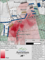
- Map depicting Field of fire map combining Federal infantry and artillery in D.R. Miller’s cornfield at approximately 7:20 a.m. Federal units that were modeled are labeled on the map.
- Hydrography, elevation, and roads data sourced from USGS with alterations by the cartographer.
- Digitization sources from the Carman-Cope Maps (Library of Congress, Geography & Map Division), and topographic maps/aerial imagery (USGS & USDA-FSA Aerial Photography Field Office).
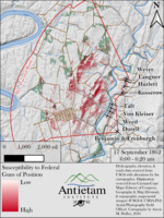
- Map depicting Field of fire map for the Federal guns of position between 6:00 and 6:20 a.m. highlighting the maximum ranges of guns considering terrain while highlighting a few selected targets for analysis.
- Hydrography, elevation, and roads data sourced from USGS with alterations by the cartographer.
- Digitization sources from the Carman-Cope Maps (Library of Congress, Geography & Map Division), and topographic maps/aerial imagery (USGS & USDA-FSA Aerial Photography Field Office).
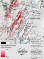
- Map depicting Field of fire map for the Federal guns of position between 6:00 and 6:20 a.m. highlighting the maximum ranges of guns considering terrain.
- Hydrography, elevation, and roads data sourced from USGS with alterations by the cartographer.
- Digitization sources from the Carman-Cope Maps (Library of Congress, Geography & Map Division), and topographic maps/aerial imagery (USGS & USDA-FSA Aerial Photography Field Office).
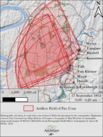
- Map depicting Field of fire cone map for the Federal guns of position between 6:00 and 6:20 a.m. highlighting the maximum ranges of guns without considering terrain,
- Hydrography, elevation, and roads data sourced from USGS with alterations by the cartographer.
- Digitization sources from the Carman-Cope Maps (Library of Congress, Geography & Map Division), and topographic maps/aerial imagery (USGS & USDA-FSA Aerial Photography Field Office).
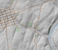
- Map depicting Portion of the digitally reconstructed 1862 “basemap”, including terrain, hydrography, roads, buildings, woodlots, orchards, rock outcrops, fences, and field cover. This basemap is available to purchase as a 24”x36” full-color poster from the Antietam Institute
- Hydrography, elevation, and roads data sourced from USGS with alterations by the cartographer.
- Digitization sources from the Carman-Cope Maps (Library of Congress, Geography & Map Division), and topographic maps/aerial imagery (USGS & USDA-FSA Aerial Photography Field Office).
Table of Contents
The Editor’s Column
Kevin R. Pawlak . . . . . 6
Antietam Institute Announcements . . 8
Feature Articles
Antietam’s Less-than-Valorous Leaders
Tom Clemens . . . . . . 10
Telling the Story on the Ground: Self-Guided Touring and the Antietam
Visitor
Wilson H. Beebe, Jr. . . . . . 38
In Their Own Words
William H. Humphrey’s 1888 Speech on Antietam
Andy Cardinal . . . . . . 64
Antietam Artifacts
Lieutenant Arthur Dehon of the 12th Massachusetts Infantry
Joseph Stahl and Matthew Borders . . . 72
In Antietam’s Footsteps
Touring the Miller Pasture
Michael Hill . . . . . . 76
Institute Interview
Sitting Down with Bob Brooks
Laura Marfut . . . . . . 82
Antietam: Then and Now
Chris Vincent . . . . . . 89
Book Reviews . . . . . . 92
Contributor Biographies 98
Antietam Institute Membership Honor Roll . 100
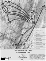
- Map depicting “McClellan on the Field, 17 September 1862.”
- Hydrography, elevation, and roads data sourced from USGS with alterations by the cartographer.
- Digitization sources from the Carman-Cope Maps (Library of Congress, Geography & Map Division), and topographic maps/aerial imagery (USGS & USDA-FSA Aerial Photography Field Office).
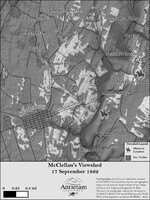
- Map depicting McClellan’s Knoll Viewshed. The Final Attack climaxed on the high ground running along the Harpers Ferry Road, 17 Sept. 1862.
- Hydrography, elevation, and roads data sourced from USGS with alterations by the cartographer.
- Digitization sources from the Carman-Cope Maps (Library of Congress, Geography & Map Division), and topographic maps/aerial imagery (USGS & USDA-FSA Aerial Photography Field Office).
- Map depicting action in and around the Burnside Bridge and the Final Attack south of Sharpsburg on 17 Sept. 1862.
- Hydrography, elevation, and roads data sourced from USGS with alterations by the cartographer.
- Digitization sources from the Carman-Cope Maps (Library of Congress, Geography & Map Division), and topographic maps/aerial imagery (USGS & USDA-FSA Aerial Photography Field Office).
Map depicting action of Simon's (Bachman’s) Battery in position near the Sunken Road, 10: 30 a.m. 17 Sept. 1862.
- Hydrography, elevation, and roads data sourced from USGS with alterations by the cartographer.
- Digitization sources from the Carman-Cope Maps (Library of Congress, Geography & Map Division), and topographic maps/aerial imagery (USGS & USDA-FSA Aerial Photography Field Office).
Table of Contents
The Editor’s Column
Kevin R. Pawlak . . . . . . 6
Antietam Institute Announcements . . . 8
Feature Articles
Hood’s Final Attack at Fox’s Gap
Steven R. Stotelmyer . . . . . 11
Mystery and Murder at Antietam
Tom and Colleen McMillan . . . . 66
Earrings and Dinner at the Deaners
John W. Schildt . . . . . 78
In Their Own Words
“It seemed almost whole lines would melt away at once”
Andy Cardinal . . . . . . 84
Antietam Artifacts
Sergeant John Johnson’s ID Tag
Joseph Stahl . . . . . . 88
In Antietam’s Footsteps
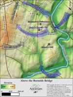
In Antietam’s Footsteps: Above the Burnside Bridge
J. O. Smith . . . . . . 92
Institute Interview
Sitting Down with John Banks
Laura L. Marfut . . . . . 97
Antietam: Then and Now
Mike Doyle . . . . . . 102
Book Reviews . . . . . . 103
Contributor Biographies . . . . 106
Antietam Institute Membership Honor Roll . 109
Table of Contents
The Editor’s Column
Kevin R. Pawlak . . . . . . 6
Antietam Institute Announcements . . . 8
Feature Articles
Lee’s Delicate Condition Steven R. Stotelmyer . . . . . 10
“Without Praise and Without Censure”: Ezra Carman and the
Antietam Battlefield Board, An Appreciation Wilson H. Beebe Jr. . . . . . 29
In Their Own Words
The Diary of Lieutenant James Simons, Bachman’s (South Carolina)
Battery, Army of Northern Virginia
James A. Rosebrock . . . . . 54
Antietam Artifacts
The Sword of Wilson Colwell, 2nd Wisconsin Infantry
Brian Wyland . . . . . . 64
In Antietam’s Footsteps
The September 1862 Harpers Ferry Battlefield J. O. Smith . . . . . . 71
Institute Interview
Sitting Down with Dennis Frye Laura L. Marfut . . . . . 75
Book Reviews . . . . . . 84
Contributor Biographies . . . . 86
Antietam Institute Membership Honor Roll . 88
James J. Broomall is an associate professor of History at Shepherd University. He serves as director of the George Tyler Moore Center for the Study of the Civil War and the Robert C. Byrd Center for Congressional History and Education. Before coming to Shepherd, Broomall most recently served as an assistant professor of History at the University of North Florida, Jacksonville, Florida. He earned his Ph.D. from the University of Florida in 2011 working under Professor William A. Link whose family, coincidentally, is from the Shepherdstown area. The University of North Carolina at Greensboro awarded his master’s degree in history and museum studies in 2006, and he earned his B.A. from the University of Delaware in 2001.
With an abiding passion for the Civil War-era, Professor Broomall has worked in diverse environments ranging from academic institutions to local museums, and developed courses, conferences, and programs of interpretation focusing on the experiences of civilians, soldiers, and slaves during the mid-Nineteenth Century. Broomall’s scholarship is dedicated to the Civil War-era. He most recently published Private Confederacies: The Emotional Worlds of Southern Men as Citizens and Soldiers as part of the University of North Carolina Press’s Civil War America series. Further, along with William A. Link, Broomall published an edited collection Rethinking American Emancipation: Legacies of Slavery and the Quest for Black Freedom (2016, Cambridge University Press). He has articles in Civil War History, Civil War Times, The Journal of the Civil War Era, and the edited volume, Creating Citizenship in the Nineteenth-Century South in addition to historiographical essays, book reviews, and online essays. Broomall has also recently completed for the National Park Service and the Organization of American Historians a study of the Chesapeake and Ohio Canal during the American Civil War, which is being used for interpretative programs, online materials, and a brochure.
He currently resides in Shepherdstown with his wife Tish and their children Simon, Henry, and Addy.
Brian Baracz is a ranger at Antietam National Battlefield with over 20 years of experience at the park. Over the years, he has written many articles, on a wide range of topics regarding the Maryland Campaign. Brian received his degree in history from UMBC. He grew up in Cleveland, OH and now lives in Frederick, MD.
Jim Rosebrock served 28 years in the US Army, including combat operations with the 82nd Airborne in Grenada, retiring at the rank of Lt. Colonel. He holds a master’s degree from the Industrial College of the Armed Forces. Jim recently retired from the Department of Justice. He was the Chief of the Antietam Battlefield Guides from 2011 to 2018. He manages two blogs, Antietam Voices, and South from the North Woods. Jim is currently the Vice President of the Antietam Institute and the author of The Artillery of Antietam.
Lucas Cade A native of Marietta, Georgia, Lucas developed an early interest in the Civil War. He received a BS in Secondary Education/History from Troy State University and a MS in Economic Development from the University of Southern Mississippi. He moved to Washington County, Maryland and has enjoyed a 35-year career in business development within the electric utility industry. Lucas has been a long-time advocate of battlefield preservation and has been active in the American Battlefield Trust and its predecessors for more than two decades. A certified guide at Antietam National Battlefield, Lucas lives in Winchester, Virginia with his wife, Julie.
Table of Contents
The Editor’s Column
Kevin R. Pawlak . . . . . . 6
Antietam Institute Announcements . . . 8
Feature Articles
Antietam’s Signatory: HENRY WINTERS NY
Tom & Colleen McMillan . . . . 10
“Credit to which it is entitled”: Perspectives on the Artillery at the Battle of Antietam James A. Rosebrock . . . . . 20
The Cast Iron Brigade Sharon A. Murray . . . . . 49
In Their Own Words
“It Shall Be Preserved” W. Charles Young . . . . . 54
Antietam Artifacts
Sergeant Edward Brackett’s Belt Buckle Nicholas P. Picerno . . . . . 59
In Antietam’s Footsteps
In Antietam’s Footsteps: Companies A and I, 5th Maryland Monument at Bloody Lane J. O. Smith . . . . . . 63
Institute Interview
Sitting Down with Dr. Susan Trail Laura L. Marfut . . . . . 66
Book Reviews . . . . . . 73
Contributor Biographies . . . . 80
Antietam Institute Membership Honor Roll . 82
The Ridout family lived on South Moutain near Crampton's Gap and witnessed the fighting that occurred there on September 14, 1862. Archie Ridout’s account vividly reveals a family living through a terrible time, including the distinctively African American aspects of their experience.
Table of Contents
The Editor’s Column Kevin R. Pawlak . . . . . . 6
Antietam Institute Announcements . . . 9
Feature Articles
Confederate Defeat at South Mountain: Robert E. Lee’s Moment of
Hesitation on the Morning of September 14, 1862
Alexander B. Rossino . . . . . 12
Caution East of Frederick: George B. McClellan in the Early Part of the Maryland Campaign Darin Wipperman . . . . . 28
Who’s the Boss? Command Turnover in Two Maryland Campaign
Regiments Frank E. Bell III . . . . . 56
In Their Own Words
“I Could Scarcely Recognize the Place” Steven Cowie . . . . . . 74
Antietam Artifacts
Reunion Ribbons of the 130th Pennsylvania Infantry Jon Tracey . . . . . . 77
In Antietam’s Footsteps
J.E.B. Stuart’s Pennsylvania Raid J.O. Smith . . . . . . 83
Institute Interview
Sitting Down with Dr. Thomas G. Clemens Laura Marfut . . . . . . 87
Book Review . . . . . . 95
On Potomac’s Waters John Schildt . . . . . . 99
Contributor Biographies . . . . 101
Antietam Institute Membership Honor Roll . ...103
- W. H. Paine, a topographical engineer, known as the Pathfinder of the Army of the Potomac, served with the Topographical Staff of the Army of the Potomac during the American Civil War.
- Map Map depicting action in and around the the battlefields of South Mountain during the Maryland Campaign, Sept. 14, 1862
- Map depicting action in and around the Harpers Ferry Road south of Sharpsburg to the Lower Bridge at approx. 5:30am, 17 Sept. 1862.
- Hydrography, elevation, and roads data sourced from USGS with alterations by the cartographer.
- Digitization sources from the Carman-Cope Maps (Library of Congress, Geography & Map Division), and topographic maps/aerial imagery (USGS & USDA-FSA Aerial Photography Field Office).
Map depicting action in and around the Reel Ridge and Piper Farm at approx. 1:00pm, 17 Sept. 1862.
- Hydrography, elevation, and roads data sourced from USGS with alterations by the cartographer.
- Digitization sources from the Carman-Cope Maps (Library of Congress, Geography & Map Division), and topographic maps/aerial imagery (USGS & USDA-FSA Aerial Photography Field Office).
- Map depicting action in and around Dunker Church north to the Cornfield at approx. 7:20am, 17 Sept. 1862.
- Hydrography, elevation, and roads data sourced from USGS with alterations by the cartographer.
- Digitization sources from the Carman-Cope Maps (Library of Congress, Geography & Map Division), and topographic maps/aerial imagery (USGS & USDA-FSA Aerial Photography Field Office).
Table of Contents
The Editor’s Column Kevin R. Pawlak . . . . . . 6
Antietam Institute Announcements . . . 8
Feature Articles
Interpretive Themes for Experiencing Antietam National Battlefield Richard P. D’Ambrisi . . . . . 10
Deception in the Forty-Acre Cornfield? Kevin R. Pawlak . . . . . 18
Very Much Diminished: Straggling in the Army of Northern Virginia in
the Maryland Campaign Russell Rich . . . . . . 34
In Their Own Words
The Lost Passages of Brig. Gen. Alfred Pleasonton’s Report of the Battle of Antietam
Kevin R. Pawlak . . . . . 61
Antietam Artifacts
Thomas Cutter, 35th Massachusetts Infantry Joseph Stahl . . . . . . 63
In Antietam’s Footsteps
Crampton’s Gap Loop Trail J.O. Smith . . . . . . 68
Institute Interview
Sitting Down with Keith Snyder Laura Marfut . . . . . . 72
Book Review . . . . . . 77
Contributor Biographies . . . . 80
Antietam Institute Membership Honor Roll . 81
The Editor’s Column - Kevin R. Pawlak . . . . . . . 6
Antietam Institute Announcements . . . 9
Feature Articles
Davis’s “Valiant Coup”: Breaking the Union Cavalry Out of Harpers Ferry,
September 14, 1862 - Sharon A. Murray . . . . . . 10
Ezra Carman’s Missing Fight - Bradley M. Gottfried . . . . . . 32
“The Bravest of the Brave…Under So Much Dirt”: Floridians in the Maryland Campaign
- Phillip S. Greenwalt . . . . . . 44
In Their Own Words John Delaney to John Gould, March 27, 1891 - Darin Wipperman . .. . . . 54
Antietam Artifacts Mansfield’s Hat for a Sword: The Collection of Capt. George Nye, 10th Maine Infantry - Nicholas P. Picerno . . . . . . 58
In Antietam’s Footsteps Goodbye Letters from the Battlefield - J.O. Smith . . . . . . . 63
Institute Interview Sitting Down with Dr. Gordon Dammann. - Laura Marfut . . . . . . . 68
Book Review . . . . . . . 75
16th Connecticut: A Valediction. - Judi McHugh . . . . . . . 78
Contributor Biographies . . . . . 79
Antietam Institute Membership Honor Roll . . 80
One of 12 volumes
CONTENTS—MARYLAND.
PAGE
CHAPTER I. Maryland in its Origin. Progress and Eventual Relations to the Confederate Movement
3
CHAPTER II. Maryland's First Patriotic Movement in 1861
15
CHAPTER III. Maryland's Overthrow
29
CHAPTER IV. Marylanders Enlist and Organize to Defend Virginia and the Confederacy
42
CHAPTER V. Marylanders in the Campaigns of 1861
50
CHAPTER VI. Marylanders in 1862 under Gens. Joseph E. Johnston and Stonewall Jackson
65
CHAPTER VII. Marylanders in 1862 under Gen. Robert E. Lee
83
CHAPTER VIII. Maryland under Federal Military Power
92
CHAPTER IX. Maryland Artillery—Second Maryland Regiment Infantry—First Maryland Cavalry
101
CHAPTER X. The Maryland Line
114
ROSTER OF MARYLAND LINE
134
APPENDIX A
145
BIOGRAPHICAL
153
ILLUSTRATIONS—MARYLAND.
FACING PAGE
Archer, James J. 168
Brent, Joseph L. 168
Elzey, Arnold 168
First Maryland at Cold Harbor 85
First Maryland Regiment, Charge of, June 6, 1862 80
Johnson, Bradley T. 1
Johnson, Bradley T. 168
Little, Henry 168
Lovell, Mansfield 168
Mackall, W. W. 168
Maryland (Map) Between pages 152 and 153
Steuart, George H. 168
Trimble, Isaac R. 168
Winder, Charles S. 168
Winder, John H. 168
CONTENTS—WEST VIRGINIA.
PAGE.
CHAPTER I. The Partition of Virginia–The Dilemma of the Old Dominion in 1861–Preparations for War–Organization of Troops in Western Virginia–The Unionist Convention–Organization of the State of West Virginia
3
CHAPTER II. McClellan's Invasion–The Affair at Philippi–Rich Mountain and Laurel Hill–Death of Garnett–Operations about Romney–Federal Occupation of the Kanawha Valley–Fight at Scary Creek–Loring at Cheat Mountain
14
CHAPTER III. Operations under Gen. R. E. Lee–Floyd and Wise in the Kanawha Valley–Battle of Carnifix Ferry–Lee's Cheat Mountain Campaign–Sewell Mountain–Camp Bartow–Camp Alleghany–Floyd's Cotton Hill Campaign
34
CHAPTER IV. Operations in the Northeast–Kelley's Campaign against Romney–Stonewall Jackson in Command in the Shenandoah Valley–His Campaign to Bath and Romney
48
CHAPTER V. Battle of McDowell–The Princeton Campaign–Loring's Advance Down the Kanawha Valley–Battle of Fayetteville–Occupation of Charleston–Jenkins Enters Ohio–Echols in Command–Imboden's Operations
56
CHAPTER VI. Operations of 1863–Jones' and Imboden's Raid against the Baltimore & Ohio Railroad–Jenkins’ Raid to Point Pleasant–Expeditions to Beverly and Wytheville–Battles of White Sulphur Springs and Droop Mountain–Averell's Raid to Salem
72
CHAPTER VII. Operations of 1864-65–Expeditions of Fitzhugh Lee and Rosser–Exploits of Gilmor and McNeill–Organization of the Army of Western Virginia–Battle of Cloyd's Mountain–New Market Lynchburg–Retreat of Hunter through West Virginia–Witcher's Raids–Other Brilliant Exploits
90
CHAPTER VIII. Miscellaneous Data–Notes on the Contributions of Various Counties to the Confederate Service–Records of the Twenty-fifth and Thirty-first Regiments
105
APPENDIX—McNeill and His Rangers. 116
BIOGRAPHICAL 129
ILLUSTRATIONS-WEST VIRGINIA.
FACING PAGE
DROOP MOUNTAIN, BATTLE (Map) 84
GAULEY BRIDGE, VICINITY OF (Map) 64
WEST VIRGINIA AND VIRGINIA, PARTS OF (Map) 96
76
WHITE, ROBERT 1
WHITE SULPHUR SPRINGS, BATTLE (Map) 84
- Title from item.
- Copyright 1862 by Alexander Gardner.
- Hand written on verso: William Pinkerton.
- Forms part of: Civil War Photograph Collection (Library of Congress).
- Original negative may be available: LC-B811-562.
- Part of series: The War for the Union. Photographic War History, 1861-1865.
- Title from item.
- Attributed to Alexander Gardner, based on LC-B811-587.
- Forms part of: Civil War Photograph Collection (Library of Congress).
- Original negative is: LC-B811-587, with different cropping.
- Part of series: The War for the Union. Photographic War History, 1861-1865.
- Title from item.
- Attributed to Alexander Gardner, based on LC-B811-568.
- Forms part of: Civil War Photograph Collection (Library of Congress).
- Original negative is: LC-B811-568.
- Title from item.
- Copyright 1862 by Alexander Gardner.
- Hand written on verso: William Pinkerton.
- Forms part of: Civil War Photograph Collection (Library of Congress).
- Signed lower right: Alf. R. Waud.
- Title inscribed below image.
- References: Ray, plate 30.
- Gift, J.P. Morgan, 1919
- Reference print available in the Civil War Drawings file 1862.
- Reference print available in Ray, Plate 30 (p. 107)
- Forms part of: Morgan collection of Civil War drawings.
- Signed lower left of image: ARW.
- Title inscribed below image.
- Inscribed vertically right margin: Genl Sumners attack.
- Gift, J.P. Morgan, 1919
- Reference print available in the Civil War Drawings file 1862.
- Forms part of: Morgan collection of Civil War drawings.
- Map depicting action in and around Sherrick’s forty-acre cornfield at approx. 4:20pm, 17 Sept. 1862.
- Hydrography, elevation, and roads data sourced from USGS with alterations by the cartographer.
- Digitization sources from the Carman-Cope Maps (Library of Congress, Geography & Map Division), and topographic maps/aerial imagery (USGS & USDA-FSA Aerial Photography Field Office).
Maps were made by Vorzet to accompany Louis Phillipe d'Orleans' (Comte de Paris) multivolume "Histoire de la Guerre Civile en Amérique". The set includes two (of three) of the original fascicle covers (this was issued in parts, and often bound later). The first fascicle was from 1874. The fascicles were issued to accompany vols. 1-2, 3-4. and 5-6 respectively of the "Histoire." The Comte de Paris was a pretender to the throne of France, and expatriate, working as an aide-de-camp to the Union Gen. George MacClellan (McClellan). He eventually settled in England. Pub Date is the latest date of the maps published over time for this series. Looseleaf in two (of the original three) paper light green fascicles. Maps are color; chromolithographs. The atlas was provided for digitization by Joel Kovarsky, and has since been donated to the Albert and Shirley Small Special Collections Library of the University of Virginia.
- "Printed by order of the Association of the Maryland Line."
- "Originally delivered in Richmond before the Association of the Army of Northern Virginia, and ... printed by the Association and published in the Southern Historical Society Papers."
Colonel Bradley Tyler Johnson
(1829 - 1903)
Home State: Maryland
Command Billet: Brigade Commander
Branch of Service: Infantry
Unit: Jones' Brigade
On the Campaign-He commanded Jones' Brigade of Jackson's Division (wounded and relieved?).
Colonel Bradley Tyler Johnson
(1829 - 1903)
Home State: Maryland
Command Billet: Brigade Commander
Branch of Service: Infantry
Unit: Jones' Brigade
On the Campaign-He commanded Jones' Brigade of Jackson's Division (wounded and relieved?).
Brigadier General James Jay Archer
(1817 - 1864)
Home State: Maryland
Education: Princeton College, Class of 1835
Command Billet: Brigade Commander
Branch of Service: Infantry
Unit: Archer's Brigade
On the Campaign-He was in command of the Archer's "Tennessee" Brigade of Hill's Light Division which arrived at Sharpsburg after an all day march from Harpers Ferry late on the afternoon of 17 September and was part of the counterattack which drove the Federal Left Wing back from Sharpsburg at the end of the battle. He had been ill and "turned over command of the Brigade to Colonel Turney (First Tennessee), under whom, with the exception of the Fifth Alabama, it marched to the battle-field of Sharpsburg, while I followed in an ambulance. " He resumed command as the Brigade formed for attack late in the afternoon of 17 September.
Brigadier General William Henry French
(1815 - 1881)
Home State: Maryland
Education: US Military Academy, West Point, NY, Class of 1837;Class Rank: 22
Command Billet: Commanding Division
Branch of Service: Artillery
Unit: 3rd Division, II Corps
On the Campaign-He commanded the Third Division of the Second Army Corps (under MGen. Edwin V. Sumner) in Maryland.
- Map depicting Pryor’s Florida brigade’s advance from the Piper farm lane to the Bloody Lane at approx. 10:30am, 17 Sept. 1862.
- Hydrography, elevation, and roads data sourced from USGS with alterations by the cartographer.
- Digitization sources from the Carman-Cope Maps (Library of Congress, Geography & Map Division), and topographic maps/aerial imagery (USGS & USDA-FSA Aerial Photography Field Office).
- This map is georeferenced and can be utilized in smartphone GPS apps.
- Map depicting Van Manning's Confederate brigade's attack east across the Hagerstown Pike at approx. 10:30am, 17 Sept. 1862.
- Hydrography, elevation, and roads data sourced from USGS with alterations by the cartographer.
- Digitization sources from the Carman-Cope Maps (Library of Congress, Geography & Map Division), and topographic maps/aerial imagery (USGS & USDA-FSA Aerial Photography Field Office).
- This map is georeferenced and can be utilized in smartphone GPS apps.
- Map depicting U.S. Cavalry route from Harpers Ferry to Greencastle and nearby Confederate columns, 14-15 Sept. 1862.
- Historic elevation digitization sourced from USGS. Hydrography, boundaries, elevation, and roads data sourced from USGS with alterations by the cartographer. Roads and landmark digitization data from OpenStreetMap and OpenStreetMap Foundation.
- This map is georeferenced and can be utilized in smartphone GPS apps.
Thure Thulstrup illustration of the Battle of Antietam with Union troops advancing toward the Dunker Church
- G33115 U.S. Copyright Office.
- "Fac-simile print by L. Prang & Co."
- Annotated in red and blue to show Union and Confederate positions.
- Map no. IX from: The story of the Civil War, vol. 2 / John C. Ropes. Boston, 1898.
- Relief shown by hachures.
- [Scale ca. 1:13,300].
- Inscribed in longhand as follows: Obtained from Washington & presented to Gen. R. E. Lee by J. E. B. Stuart.
- This map was in the possession of Jedediah Hotchkiss at the time of his death. Major Hotchkiss served as topographic engineer with the Army of Northern Virginia. In July 1948, the Library of Congress purchased his map collection.
- Description derived from published bibliography.
- Relief shown by hachures.
- Map is annotated by hand to show the Confederate positions in red, additional hachures in pencil and blue ink,and a 3/4-inch grid.
- Description derived from published bibliography.
- This map was in the possession of Jedediah Hotchkiss at the time of his death. Major Hotchkiss served as topographic engineer with the Army of Northern Virginia. In July 1948, the Library of Congress purchased his map collection.
- "Sketched from a point north of Antietam Creek and west of the turnpike. Charge of Genl. Sumner's Corps on centre of the enemy's position in the lane in front of the town" on mount.
- Includes numerical key.
- Gift, J.P. Morgan, 1919 (DLC/PP-1919:R1.1.265)
- Forms part of: Morgan collection of Civil War drawings.
- Caption from negative sleeve: Gen. Hooker's Headquarters, Battle of Antietam.
- Corresponding print is in LOT 4167-C.
- Credit line: Civil war photographs, 1861-1865, Library of Congress, Prints and Photographs Division.
- Caption from negative sleeve: Dunker [?] Church, Antietam.
- Corresponding print is in LOT 4167-C.
- Credit line: Civil war photographs, 1861-1865, Library of Congress, Prints and Photographs Division.
- Civil War photographs, 1861-1865 / compiled by Hirst D. Milhollen and Donald H. Mugridge, Washington, D.C. : Library of Congress, 1977. No. 0148
- Title from Milhollen and Mugridge.
- Additional information from Katz, D. Mark. Witness to an era: the life and photographs of Alexander Gardner, 1991.
- Credit line: Civil war photographs, 1861-1865, Library of Congress, Prints and Photographs Division.
- "Entered according to act of Congress, in the year 1862, by Alex. Gardner, in the Clerk's Office of the District Court of the District of Columbia."
- Title from item. Date printed on photo is Oct. 4, but the photo was probably taken on Oct. 3.
- Published in: Lincoln's photographs: a complete album / by Lloyd Ostendorf. Dayton, OH: Rockywood Press, 1998, p. 111.
- Stereo filed in LOT 4168.
- Photographer name from negative sleeve: Alexander Gardner.
- Caption from negative sleeve: View of Antietam Battlefield where Sumner's Corps charged the enemy. Scene of terrific conflict. Sept. 1862.
- Two plates form left (LC-B811-568B) and right (LC-B811-568A) halves of a stereograph pair.
- Corresponding print is in LOT 4167-C.
- Credit line: Civil war photographs, 1861-1865, Library of Congress, Prints and Photographs Division.
- Caption from negative sleeve: Burying the dead, after the Battle of Antietam.
- Two plates form left (LC-B811-561B) and right (LC-B811-561A) halves of a stereograph pair.
- Corresponding print is in LOT 4168.
- Credit line: Civil war photographs, 1861-1865, Library of Congress, Prints and Photographs Division.
- Caption from negative sleeve: Dead on the Battlefield of Antietam.
- Credit line: Civil war photographs, 1861-1865, Library of Congress, Prints and Photographs Division.
- Photographer name from negative sleeve: Alex. Gardner.
- Caption from negative sleeve: A lone grave on battlefield of Antietam.
- Two plates form left (LC-B811-570B) and right (LC-B811-570A) halves of a stereograph pair.
- Corresponding print is in LOT 4168.
- Credit line: Civil war photographs, 1861-1865, Library of Congress, Prints and Photographs Division.
- Civil War photographs, 1861-1865 / compiled by Hirst D. Milhollen and Donald H. Mugridge, Washington, D.C. : Library of Congress, 1977. No. 0128
- Title from Milhollen and Mugridge.
- Corresponding print is in LOT 4176.
- Credit line: Civil war photographs, 1861-1865, Library of Congress, Prints and Photographs Division.
- Civil War photographs, 1861-1865 / compiled by Hirst D. Milhollen and Donald H. Mugridge, Washington, D.C. : Library of Congress, 1977. No. 0150
- Title from Milhollen and Mugridge.
- Corresponding print is in LOT 4172-F.
- Credit line: Civil war photographs, 1861-1865, Library of Congress, Prints and Photographs Division.
- Two plates form left (LC-B811-582A) and right (LC-B811-582B) halves of a stereograph pair.
- Corresponding print is in LOT 4164-C.
- Credit line: Civil war photographs, 1861-1865, Library of Congress, Prints and Photographs Division.
- Title from Civil War caption books.
- Caption from negative sleeve: Miller's house, Antietam, Md.
- Corresponding print is in LOT 4165-C.
- Credit line: Civil war photographs, 1861-1865, Library of Congress, Prints and Photographs Division.
- Civil War photographs, 1861-1865 / compiled by Hirst D. Milhollen and Donald H. Mugridge, Washington, D.C. : Library of Congress, 1977. No. 0153
- Title from Milhollen and Mugridge.
- Credit line: Civil war photographs, 1861-1865, Library of Congress, Prints and Photographs Division.
Civil War photographs, 1861-1865 / compiled by Hirst D. Milhollen and Donald H. Mugridge, Washington, D.C. : Library of Congress, 1977. No. 0129
- Title from Milhollen and Mugridge.
- Credit line: Civil war photographs, 1861-1865, Library of Congress, Prints and Photographs Division.