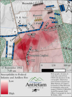
- Map depicting Field of fire map combining Federal infantry and artillery in D.R. Miller’s cornfield at approximately 7:20 a.m. Federal units that were modeled are labeled on the map.
- Hydrography, elevation, and roads data sourced from USGS with alterations by the cartographer.
- Digitization sources from the Carman-Cope Maps (Library of Congress, Geography & Map Division), and topographic maps/aerial imagery (USGS & USDA-FSA Aerial Photography Field Office).
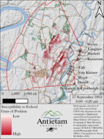
- Map depicting Field of fire map for the Federal guns of position between 6:00 and 6:20 a.m. highlighting the maximum ranges of guns considering terrain while highlighting a few selected targets for analysis.
- Hydrography, elevation, and roads data sourced from USGS with alterations by the cartographer.
- Digitization sources from the Carman-Cope Maps (Library of Congress, Geography & Map Division), and topographic maps/aerial imagery (USGS & USDA-FSA Aerial Photography Field Office).
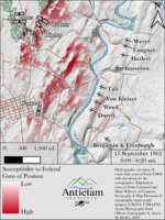
- Map depicting Field of fire map for the Federal guns of position between 6:00 and 6:20 a.m. highlighting the maximum ranges of guns considering terrain.
- Hydrography, elevation, and roads data sourced from USGS with alterations by the cartographer.
- Digitization sources from the Carman-Cope Maps (Library of Congress, Geography & Map Division), and topographic maps/aerial imagery (USGS & USDA-FSA Aerial Photography Field Office).
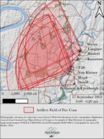
- Map depicting Field of fire cone map for the Federal guns of position between 6:00 and 6:20 a.m. highlighting the maximum ranges of guns without considering terrain,
- Hydrography, elevation, and roads data sourced from USGS with alterations by the cartographer.
- Digitization sources from the Carman-Cope Maps (Library of Congress, Geography & Map Division), and topographic maps/aerial imagery (USGS & USDA-FSA Aerial Photography Field Office).
- Map depicting Portion of the digitally reconstructed 1862 “basemap”, including terrain, hydrography, roads, buildings, woodlots, orchards, rock outcrops, fences, and field cover. This basemap is available to purchase as a 24”x36” full-color poster from the Antietam Institute
- Hydrography, elevation, and roads data sourced from USGS with alterations by the cartographer.
- Digitization sources from the Carman-Cope Maps (Library of Congress, Geography & Map Division), and topographic maps/aerial imagery (USGS & USDA-FSA Aerial Photography Field Office).
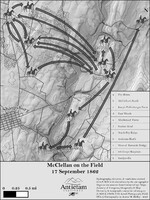
- Map depicting “McClellan on the Field, 17 September 1862.”
- Hydrography, elevation, and roads data sourced from USGS with alterations by the cartographer.
- Digitization sources from the Carman-Cope Maps (Library of Congress, Geography & Map Division), and topographic maps/aerial imagery (USGS & USDA-FSA Aerial Photography Field Office).
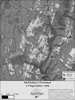
- Map depicting McClellan’s Knoll Viewshed. The Final Attack climaxed on the high ground running along the Harpers Ferry Road, 17 Sept. 1862.
- Hydrography, elevation, and roads data sourced from USGS with alterations by the cartographer.
- Digitization sources from the Carman-Cope Maps (Library of Congress, Geography & Map Division), and topographic maps/aerial imagery (USGS & USDA-FSA Aerial Photography Field Office).
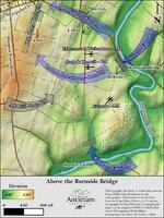
- Map depicting action in and around the Burnside Bridge and the Final Attack south of Sharpsburg on 17 Sept. 1862.
- Hydrography, elevation, and roads data sourced from USGS with alterations by the cartographer.
- Digitization sources from the Carman-Cope Maps (Library of Congress, Geography & Map Division), and topographic maps/aerial imagery (USGS & USDA-FSA Aerial Photography Field Office).
Map depicting action of Simon's (Bachman’s) Battery in position near the Sunken Road, 10: 30 a.m. 17 Sept. 1862.
- Hydrography, elevation, and roads data sourced from USGS with alterations by the cartographer.
- Digitization sources from the Carman-Cope Maps (Library of Congress, Geography & Map Division), and topographic maps/aerial imagery (USGS & USDA-FSA Aerial Photography Field Office).
- W. H. Paine, a topographical engineer, known as the Pathfinder of the Army of the Potomac, served with the Topographical Staff of the Army of the Potomac during the American Civil War.
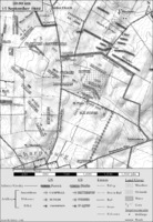
- Map Map depicting action in and around the the battlefields of South Mountain during the Maryland Campaign, Sept. 14, 1862
- Map depicting action in and around the Harpers Ferry Road south of Sharpsburg to the Lower Bridge at approx. 5:30am, 17 Sept. 1862.
- Hydrography, elevation, and roads data sourced from USGS with alterations by the cartographer.
- Digitization sources from the Carman-Cope Maps (Library of Congress, Geography & Map Division), and topographic maps/aerial imagery (USGS & USDA-FSA Aerial Photography Field Office).
Map depicting action in and around the Reel Ridge and Piper Farm at approx. 1:00pm, 17 Sept. 1862.
- Hydrography, elevation, and roads data sourced from USGS with alterations by the cartographer.
- Digitization sources from the Carman-Cope Maps (Library of Congress, Geography & Map Division), and topographic maps/aerial imagery (USGS & USDA-FSA Aerial Photography Field Office).
- Map depicting action in and around Dunker Church north to the Cornfield at approx. 7:20am, 17 Sept. 1862.
- Hydrography, elevation, and roads data sourced from USGS with alterations by the cartographer.
- Digitization sources from the Carman-Cope Maps (Library of Congress, Geography & Map Division), and topographic maps/aerial imagery (USGS & USDA-FSA Aerial Photography Field Office).
- Map depicting action in and around Sherrick’s forty-acre cornfield at approx. 4:20pm, 17 Sept. 1862.
- Hydrography, elevation, and roads data sourced from USGS with alterations by the cartographer.
- Digitization sources from the Carman-Cope Maps (Library of Congress, Geography & Map Division), and topographic maps/aerial imagery (USGS & USDA-FSA Aerial Photography Field Office).
- Annotated in red and blue to show Union and Confederate positions.
- Map no. IX from: The story of the Civil War, vol. 2 / John C. Ropes. Boston, 1898.
- Relief shown by hachures.
- [Scale ca. 1:13,300].
- Inscribed in longhand as follows: Obtained from Washington & presented to Gen. R. E. Lee by J. E. B. Stuart.
- This map was in the possession of Jedediah Hotchkiss at the time of his death. Major Hotchkiss served as topographic engineer with the Army of Northern Virginia. In July 1948, the Library of Congress purchased his map collection.
- Description derived from published bibliography.
- Relief shown by hachures.
- Map is annotated by hand to show the Confederate positions in red, additional hachures in pencil and blue ink,and a 3/4-inch grid.
- Description derived from published bibliography.
- This map was in the possession of Jedediah Hotchkiss at the time of his death. Major Hotchkiss served as topographic engineer with the Army of Northern Virginia. In July 1948, the Library of Congress purchased his map collection.